
Key Takeaways & Executive Findings
- •• Standalone positioning technologies are inadequate in complex low-altitude settings; multi-source fusion and UAV swarm cooperative positioning are identified as pivotal future trends. • A novel “space−air−ground” integrated and cooperative positioning architecture centered on GNSS and 5G is proposed for low-altitude intelligent networks. • The three-layer (ground, aerial, space) architecture reuses existing infrastructure to reduce deployment costs and deeply integrates communication and navigation capabilities. • The proposed framework enhances positioning robustness and provides cost-effective, ubiquitous, and highly reliable positioning services, while highlighting promising research directions for LAIN.
Abstract
The rapid expansion of the low-altitude economy is driving strong demand for highly accurate and reliable positioning technologies to support diverse aerial operations. This review examines core positioning methodologies within the low-altitude intelligent network (LAIN) framework, beginning with an analysis of positioning requirements and performance metrics for low-altitude flight scenarios. It systematically assesses the principles, strengths, and limitations of mainstream positioning systems, including Global Navigation Satellite Systems (GNSS), terrestrial wireless positioning, and autonomous navigation, and it surveys prevalent integrated and cooperative positioning schemes. Our analysis demonstrates that standalone positioning technologies are inadequate in complex low-altitude settings, underscoring the pivotal role of multi-source fusion and unmanned aerial vehicle (UAV) swarm cooperative positioning as future trends. To address infrastructure gaps and high deployment costs in current LAIN systems, we propose a “space−air−ground” integrated and cooperative positioning architecture centered on GNSS and the 5th generation mobile communication technology (5G). The ground layer integrates 5G and GNSS for wide-area enhanced positioning. The aerial layer uses 5G aircraft-to-everything (A2X) and sidelink (SL) communications to build self-organizing networks for cooperative UAV localization. The space layer leverages low Earth orbit (LEO) satellites to overcome coverage limitations in communication and positioning. This hierarchical architecture reduces deployment costs through infrastructure reuse and enables deep integration of communication and navigation capabilities. By supporting collaborative enhancement across all three domains, the framework improves positioning robustness and delivers cost-effective, ubiquitous, and highly reliable positioning services. Finally, we outline promising research directions. This review aims to provide a systematic reference and a novel architectural perspective for the ongoing development of LAIN.
1. Introduction
In recent years, rapid advances in low-altitude aviation technologies—such as unmanned aerial vehicles (UAVs) and electric vertical takeoff and landing aircraft—have accelerated the global low-altitude economy (LAE), making it a key growth area and a strategic focus for many countries. China has explicitly elevated LAE to a national strategic priority. As low-altitude activities expand, flight operations have become more frequent, increasing demands on safety, efficiency, and intelligent traffic management. The low-altitude intelligent network (LAIN), as the core infrastructure of LAE, plays a critical role in ensuring flight safety. By integrating communication, navigation, surveillance, and meteorological technologies, LAIN enables real-time monitoring, precise positioning, and intelligent scheduling of low-altitude aircraft. Among these capabilities, positioning and navigation systems are particularly essential. High-precision and highly reliable positioning provides accurate location information that supports safe flight in complex low-altitude environments.
Low-altitude flight environments present unique challenges. Urban canyons cause multipath signal interference, electromagnetic noise can degrade signal quality, and adverse weather can induce trajectory deviations. These conditions place greater demands on positioning technologies. Each of the existing methods, such as Global Navigation Satellite Systems (GNSS), radio-based positioning, Inertial Navigation System (INS), visual localization, and natural-field positioning, has strengths and limitations in terms of accuracy and reliability. No single positioning technology can meet the diverse and demanding requirements of the LAE.
In addition, the current positioning infrastructure is fragmented and lacks sufficient coverage to support large-scale and continuous low-altitude operations. Consequently, many local regions have independently deployed low-altitude navigation networks, leading to redundant construction and inefficient resource use.
Loading authentic research manuscript (Pages 1–5)...
Yao JIN, Zhongliang DENG, He ZHANG, Zhenke DING, Xiongyan TANG, Zelin WANG (2025). A review of UAV positioning in LAIN: toward a 5G-core “space−air−ground” integrated and cooperative architecture. Engineering Information Technology & Electronic Engineering. https://doi.org/10.1631/ENG_ITEE_2025_0127
Research & Educational Purpose Only:The translations, structured abstracts, analytical annotations, and data reports provided by SinoTechIntel are intended exclusively for academic research, internal corporate R&D, and educational benchmarking. They do not constitute formal engineering, chemical safety, legal, or professional advice.
Copyright & Intellectual Property Notice: Original copyright of the underlying source articles and experimental data remains with the respective authors, institutions, and original publishing journals. SinoTechIntel claims intellectual property only over its proprietary translations, analytical syntheses, and AEO structured enhancements in accordance with international fair use and academic citation principles.
Frequently Asked Questions
What is the low-altitude intelligent network (LAIN)?
LAIN is the core infrastructure of the low-altitude economy (LAE). It integrates communication, navigation, surveillance, and meteorological technologies to enable real-time monitoring, precise positioning, and intelligent scheduling of low-altitude aircraft, thereby ensuring flight safety.
Why are standalone positioning technologies inadequate for UAVs in low-altitude environments?
Low-altitude environments present challenges such as urban canyon multipath interference, electromagnetic noise, and adverse weather. Each individual technology—GNSS, radio-based positioning, INS, visual localization, and natural-field positioning—has strengths and limitations, but none can simultaneously deliver the required accuracy and reliability in complex low-altitude settings.
What architecture does this paper propose for UAV positioning?
The paper proposes a “space−air−ground” integrated and cooperative positioning architecture centered on GNSS and 5G. The ground layer integrates 5G and GNSS for wide-area enhanced positioning, the aerial layer uses 5G A2X and sidelink communications for cooperative UAV localization, and the space layer leverages LEO satellites to overcome coverage limitations.
How does the proposed architecture reduce deployment costs?
The architecture reduces deployment costs by reusing existing infrastructure across the ground, aerial, and space layers. This infrastructure reuse enables deep integration of communication and navigation capabilities, delivering cost-effective positioning services without the need for entirely new dedicated systems.
What are the future research directions for LAIN positioning?
While the paper outlines promising research directions, the key forward-looking themes include advancing multi-source fusion techniques, enhancing UAV swarm cooperative positioning, optimizing integration of communication and navigation, and further developing space–air–ground collaborative mechanisms to achieve ubiquitous and highly reliable positioning.
Related Technical Papers & Translations
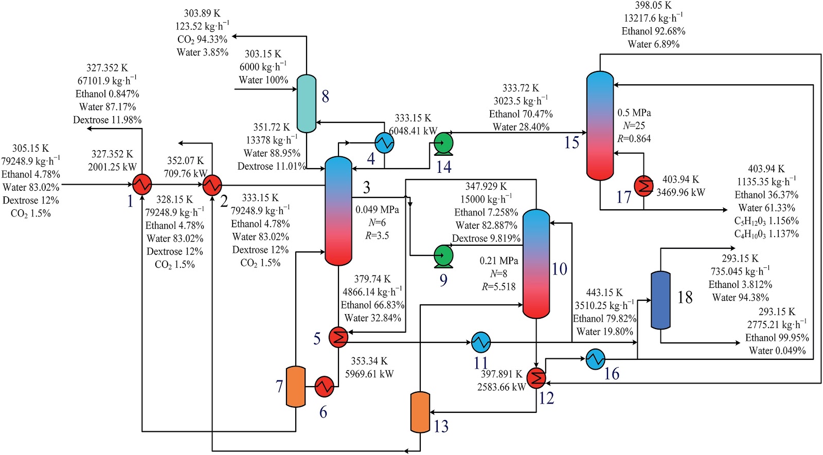
Design and optimization of a high-efficiency distillation process for cellulosic fuel ethanol integrated with thermal coupling and molecular sieve adsorption
To address the challenges of high energy consumption and prominent costs in the traditional three-columns distillation process for cellulosic fuel ethanol, a distillation—molecular sieve coupling separation process is proposed. This process integrates a three-column (crude distillation column, first distillation column, second distillation column) system with a 3A molecular sieve adsorption deep dehydration unit. A thermal coupling network is constructed via differential pressure design (steam from medium/high-pressure columns as mutual heat sources, reboiler liquid waste heat for feed preheating), and molecular sieve adsorption conditions are optimized. The study first performs a thermodynamic consistency test on the ethanol—water system, determines optimal non-random two-liquid (NRTL) model binary interaction parameters via experimental data regression for Aspen Plus simulation. Aiming at minimum total annual cost (TAC), Aspen Plus is used to optimize process parameters (theoretical tray number, feed location, reflux ratio, side-draw position, etc.). Economic analysis shows this process reduces CO2 emission costs by 27.56%, TAC by 15.58% (to 5.123 × 10⁶ USD·a-1), and increases ethanol purity to >99.6%, providing an effective solution for green, efficient separation.
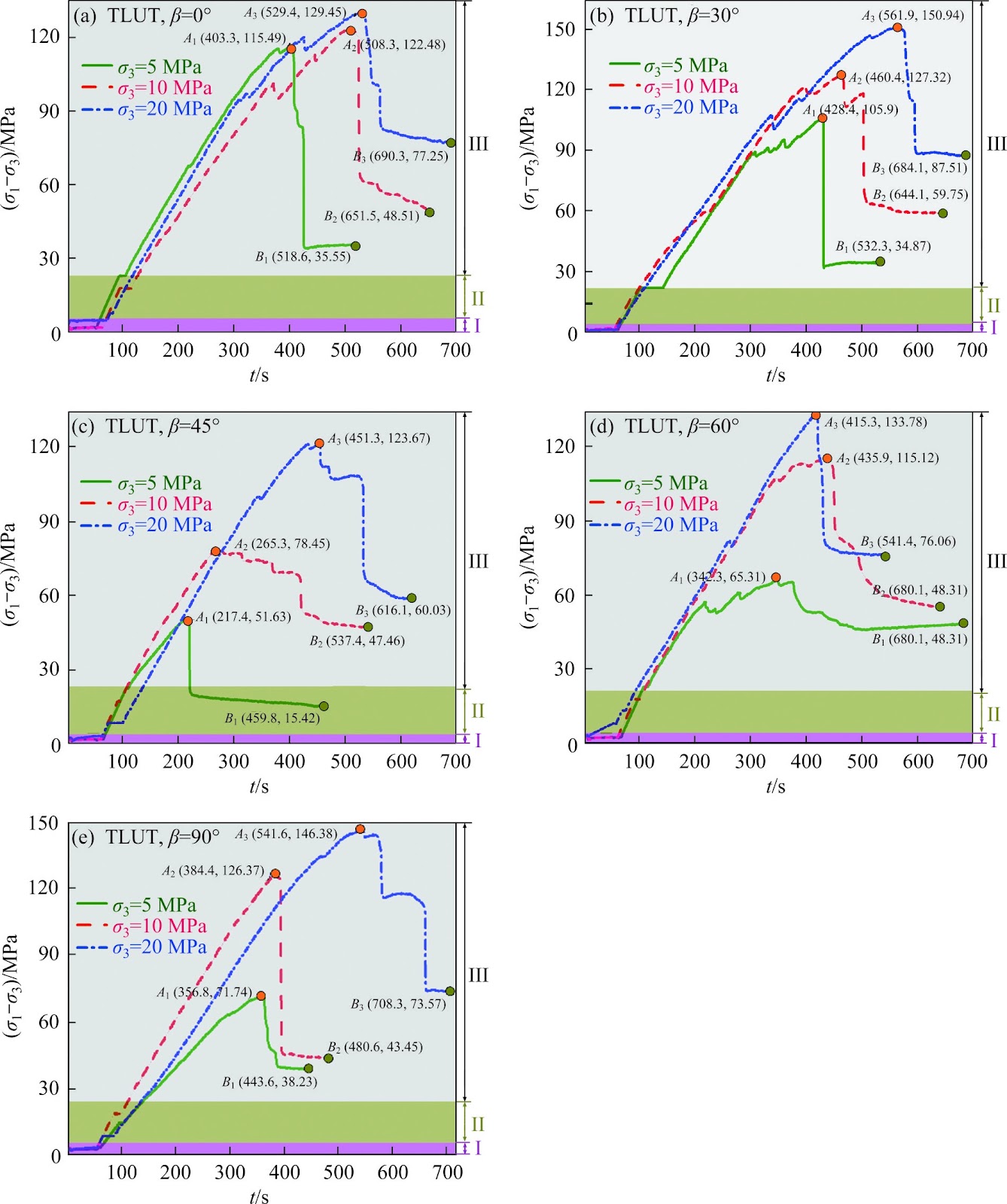
A cohesion loss model for determining residual strength of deep bedded sandstone
Rock residual strength, as an important input parameter, plays an indispensable role in proposing the reasonable and scientific scheme about stope design, underground tunnel excavation and stability evaluation of deep chambers. Therefore, previous residual strength models of rocks established were reviewed. And corresponding related problems were stated. Subsequently, starting from the effects of bedding and whole life-cycle evolution process, series of triaxial mechanical tests of deep bedded s
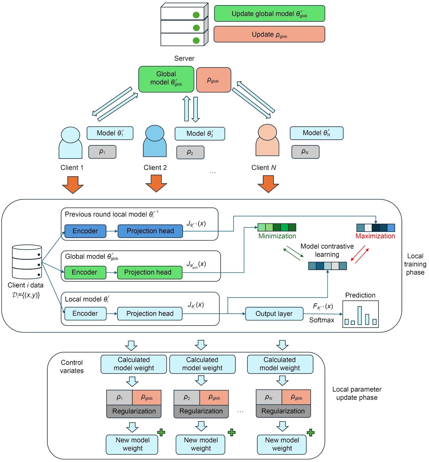
Federated model with contrastive learning and adaptive control variates for human activity recognition
Recent attention to privacy issues demands a communication-safe method for training human activity recognition (HAR) models on client activity data. Federated learning (FL) has become a compelling technique to facilitate model training between the server and clients while preserving data privacy. However, classical FL methods often assume independent and identically distributed (IID) data among clients. This assumption does not hold true in practical scenarios. Human activity in real-world scena